Wednesday, January 30, 2008

Patriot Hills

At long last, some pictures from Patriot Hills! More coming soon.


Our mode of transportation to and from the Patriot Hills was an LC-130 Hercules. It's equiped with skis that allow it to land it land in the deep field. The skis are proprietary technology and is what allows the US and no other countries to have a major presence in the interior of the continent.


Inside the air frame. It's pretty cramped inside with all of our equipment. Note that the seats are merely cargo nets strapped to the walls of the plane. Beats the heck out of flying commercial!


Here's a shot of our twin otter at the Patriot Hills camp. This is the air frame we used to get to our station sites from the camp. It can land in some pretty tight spaces. Our pilot, Jim, was a pro and getting in and out of some very tricky sites. At one place we had to land, slow our momentum so we didn't crash into an escarpment, then take off and land again on some blue ice, then taxi over to the edge of another escarpment where we installed our seismic station.


This is a shot of our science tent where we worked on prepping the equipment to go to the field. This type of tent is called a weather haven.


Here are some shots of the galley where we ate all of our meals. The cooks were incredible. We ate sushi, currys, steak, chili, pasta, and all kinds of good stuff. All of the food came from Chile.


Audrey and myself hauling some equipment to the science tent.


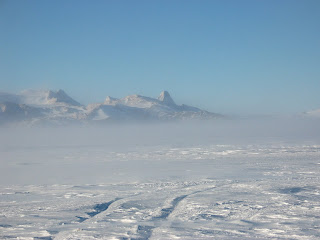
Here are some shots of the scenery from camp. It was a truly beautiful and majestic place.


The science tent.


Some more shots from camp. I really like these because you get a sense of the blowing snow and the high winds.


These little tents are called clam shells. This is were we slept when we weren't working. They were pretty nice. There were mattresses and a small table inside and just enough room to stand up and change your clothes.


Thursday, January 24, 2008

Success!

Hello everyone,

Greetings from McMurdo. We are back in town after a successful expedition to our field camp in the Patriot Hills. We spent two weeks out there and got all of our stations installed - 5 seismic and 6 GPS. It was a great time and I have lots of pictures to go through and post. I'll be working on those over the next few days so there will be lots of updates in the near future. We have four stations left to install from McMurdo and then I will return home. Right now it looks like that will be sometime in mid-February. I look forward to seeing you all soon. Thanks for all the comments and keep them coming.

Here are some replies to the comments I have received so far.

Mark, Amy - I know I should be wearing a coat, but actually it is pretty warm a lot of the days at McMurdo (plusing I'm wearing some thermals under my outer layer so it is not so bad). When the sun is out and at its highest point and there is no wind, the temperature can get as high as 35-40F. However, when the sun is low and it is cloudy and the wind picks up it can get pretty cold, more like 15-20F. At most of our field sites it is considerably colder and I can assure that I wear my coat and multiple layers of thermal underwear out there. Also, as most of you know there is 24 hours of daylight here during the summer and 24 hours of darkness during the winter (It is summer in the southern hemisphere right now). So during the daytime hours the sun is a little higher in the sky so it gets a little warmer, and during the evening it gets a little lower so it gets cooler. But the sun won't set again here until late February. Until then it just spins around in the sky providing constant sunshine and some warmth. The main things that affect the temperature at a given location here are the elevation and the wind speed. Obviously, the higher you go, the colder it gets. McMurdo is on a island and located right at sea level so it is not so bad. Our field sites, however, range from about 1500 ft to 8500 ft above sea level. But the thing that really gets you is the wind. The winds here, known as katabatic winds, can be brutal and are the highest sustained winds recorded on earth. Sometimes as much as 200 mph! This occurs when air from the top of the frigid Antarctic ice sheet (also known as the polar plateau, elevation >10,000 ft, avg temp -30 to -50F) cools, loses density, and descends rapidly to lower elevations. There were some days at Patriot Hills where the wind would literally knock you over if you did not have a firm foothold in the ground. It was amusing trying to walk from one place to another during the katabatic winds because you would have to lean into the wind to make progress, but then the wind let up for a second and you would fall flat on your face!

Andy - Good to hear from you! I'm glad you found the blog. And you're right, everything is delicious compared to a chunk of pemmican! This place is just like scout camp for grown ups. I know all of our scouting buddies would love it here. Below is a picture of me enjoying one of those survival bars.


Kaare - Don't you worry, I've got lighters for all! And something else for you I know you like to collect.

Krystal - Stephanie, from the Glamour article, is a member of our field team. She is in the group picture of the deployment photos.

Michelle - Yes, that news article is about our group. Doug is my advisor at WashU. I think they're planning to run another story when we get back and I may get interviewed for it. The link for those of you that missed the previous article is

http://www.ksdk.com/news/news_article.aspx?storyid=135868

Thanks for posting!

And speaking of news articles, here's another link to a news article from the New Zealand Press about the Basler crash with quotes from my blog!

http://www.stuff.co.nz/stuff/4335674a12.html

Brian - I did not get a chance to participate in the Scott's hut run. I didn't find out about it until it was too late!

Ryan - Don't know if I'll get a chance to do some fly fishing or not. I looked into it on my way down and it is pretty expensive for license, transportation, gear, guide, etc. You know I'll be ready as soon as I get home though! Should be right in time for opening weekend too. I've got lunker fever!

Ok, that's all for now. Sorry if I missed your comment. I think some of them got deleted somehow. I have lots of pictures, maps, and other fun stuff that I'll be posting soon.

Sunday, January 6, 2008

Castle Rock

Hello everybody,

Greetings from McMurdo. Yes, we are still in McMurdo. The weather has prevented us from getting to our deep field site for two weeks now! And unfortunately, the completion of our project is in jeopardy unless we can get out immediately and have perfect weather for the next two weeks. But you can't control the weather so we will install as many stations as we can in the time we have. In the meantime, I have been taking advantage of the Ross Island trail system (McMurdo is actually on a volcanic island, Ross Island in particular). So I've posted some pictures from my most recent hike to Castle Rock with my friends Russ and Lou. Castle Rock is an old volcanic plug or volcanic neck. It was formed when lava hardened in the vent of an active volcano. Subsequent erosion has removed the surrounding rock leaving behind the erosion-resistant plug that produces the distinctive landform shown in the picture below. The trail was about seven miles round trip. You can check out our route on the map below (yellow trail). And of course we made the side trip and climbed to the top of the rock. What a view! The pictures just don't do it justice. All in all it was a great hike and a great experience, despite the fact that it was pretty cold (15-20F) with a steady wind of about 30-35 mph. The wind is what kills you. But we got bundled up and braved the elements anyway. Hope you enjoy the pics!


Castle Rock trail.


Me and my friend Lou. I'm on the left.


Me near the base of the rock. Some clouds started to move in once we finally got there.


Some shots of us climbing to the top. It was a pretty good climb but manageable. They have some ropes set up to help you get to the top. There is no way we would have made it without the ropes and metal cleats on our boots. It is a long fall to the bottom if you slip on the ice!


Me at the top!


View of the top. The dark colored rock is the lava tube or plug itself. The reddish brown rock is the surrounding rock that is being eroded away.


My friend Russ at the top.


Me at the top.


Me and Russ at the top.

Thursday, January 3, 2008

disc golf

Yes, there is a disc golf course in Antarctica! We have been delayed for about two weeks now getting in the field so this is how I've been killing some time. We are finally scheduled to fly tomorrow so hopefully the weather holds and we can get some work done.


Hole #6 - I would call this the signature hole of the course. On a clear day there is a magnificent view of Mactown and across the Ross Sea to the Transantarctic Mts. Unfortunately the day we brought a camera with us it was cloudy. It's a nine hole course, but we frequently make up our own holes to extend it a little. Or sometimes we'll play the course forwards and then backwards to make it 18. For the final hole, you have to hit the side of Gallaghers (the beer bar) with your disc. Then we go inside and whoever takes the most strokes to do it buys a round.


Me throwing some discs. Check out that form!


My friends Russ (top two photos) and Lou (lower photo).


It's pretty easy to lose your disc amidst all the debris. One day mine ended up in this little compartent of a tractor. It took us 45 mins to find it!


Ah, the greenhouse. They grow lettuce, tomatoes, herbs, and other stuff here for use in the cafeteria. We usually stop here during a round and drink a beer. The mirrors on the wall make for some good photos. No photoshop!